This is the story of our 5 day journey deep in to the back country of Kings Canyon National Park. As I sit down and write this trip report I've been reflecting on those 5 days and what an amazing trip it was. This was the perfect High Sierra trip!

Pictured above is the Whaleback located in Cloud Canyon of Kings Canyon National Park. Haven't heard of it? Not too surprised, its somewhat of a Sierra obscurity. I myself wasn't too familiar with what it was or where it was located until about a year ago. You'll see it from time to time in scenic photo books of the high sierra. I've also seen it pictured in calendars etc. However, where I distinctly remember it being pictured was on the Sequoia/Kings Canyon National Park entrance brochure that the rangers hand to you at the gate. I mean that brochure has the 'big hitters' pictured in it - Mineral King, Evolution, and Rae Lakes. Then there is this one random picture with an amazing looking granite tower with a beautiful glaciated valley next to it - The Whaleback. I figured if it was brochure worthy then it was good enough for me.
Going to the Whaleback was just the opening 'reason' to start scoping out a trip in the area. After last summer's 4 days trip back to the Mono Recesses which was completely new territory, I vowed to explore a new section of the Sierra this year. I'll admit checking off 14er's from the east side, I've been able to look down on the rest of the park. However, this is not the same as actually "being there." So with a vow to explore new western sierra country, what better place to start than literally one of the shortest drives from my house? - Kings Canyon and a journey to the Whaleback.
Alright, so that is the back story to this trip. I recruited Nate for this voyage. He's solid in the back country, good conversation, and loves to be off the beaten path in the back country.
But before I launch of in to the trip report, I'll explain a little bit more about why we took the route we did. Again the Whaleback was just the initial reason to check this area out, so this isn't just an out-and-back from the car. I had assumed the only way to southern Kings Canyon was from Road's End. In fact, plenty of times before hiking along the Bubbs Creek trail I've passed the trail intersection for Avalanche Pass to Roaring River.
- Roaring River is located a the foot of both Cloud Canyon and Deadman's Canyon. There is a Ranger station here at the trail intersections. The trail up Cloud Canyon leads to Colby Pass which drops into the upper Kern where after many miles it meets the High Sierra Trail near the John Muir Trail. The trail up Deadman's Canyon is the Elizabeth Pass trail, which drops in the middle fork of the Kaweah drainage (Sequoia Park) where it eventually joins the High Sierra Trail at Bearpaw.
- An often neglected alternative is to approach these places from the west via the Sugarloaf Trail from Big Meadow/Horse Corral Meadow Road. Granted, this approach is long (25 miles+) but it has none of the severe ups and downs of the other alternatives. Besides, the view of the Whaleback rising above Big Wet Meadow is worth the long hike.
More and more internet research revealed that indeed most people were approaching the Whaleback from the west on the Sugarloaf trail. I had been to Big Meadow several times before, but had no idea that the road kept going. So opposed to the approach from Road's End with climbing over Avalanche pass and then dropping back down in to Roaring River, we would start at the Marvin Pass trail head located outside the park boundary and approach Roaring River on the Sugarloaf trail.
By all accounts, it looked like about 21 miles back to the Whaleback from the Marvin pass trail head. A return slog through the forest didn't sound too fun and after chatting over some ideas with Nate, he suggested a car shuttle with an exit somewhere in the Lodepole area.
It would take some time, but we eventually narrowed down a trip itinerary which involved approaching the Whaleback from Roaring River. Afterwards, we would then cross what is known as Copper Mine pass.
- Copper Mine Pass - Class 2 - 11,960'. This is a cross country pass which connects Cloud Canyon and Deadman's Canyon. Secor's description is accurate and even acknowledges that, "The name of this pass has been misplaced atop of Peak 12,345'." But here is the issue. Upon further research about this pass, more and more questions started to open up.
- Historic People And Places: Copper Mine Pass
- Give the above link a read and you'll find there is actually a lot of history about this pass. So much history in fact, I had to see this "road" so to speak. Additional online forum posts indicated that the "legit" Coppermine pass DID indeed cross the divide between Cloud Canyon and Deadman's Canyon ATOP Peak 12,345'. Technically, it crosses from Cloud Canyon over to the Kaweah drainage skirting the summit and then following the ridge between the Kaweah side and Deadman's canyon. Secor's Copper Mine pass description works, but is not the real one, so it's apparently been named Copper Mine New among people in the know.
- This cross country pass doesn't need too much explanation. It is located about 0.5 miles northwest of Elizabeth Pass and is class 1. It is also known as "Fin Pass". It is one of the passes used on the Sierra High route trans ski tour.
- The Tablelands are an incredibility flat glaciated tundra in the High Sierra. It is a pretty popular cross country destination due the proximity of some major trail heads. Here is a good read on the area. A VISIT TO THE TABLELANDS
Monday August 22nd 2016 - Marvin Pass TH - Roaring River:
Our day started off accomplishing the car drop off and shuttle. While Nate picked up a wilderness permit at Grant's Grove, I drove to the Wolverton parking lot trail head and waited. Within a few minutes he showed up and we were off driving back along the Generals Highway to the Big Meadow turnoff.
We reached the Marvin Pass trail head shortly before 11am after a much further than I thought drive back on the Big Meadow road. Scope it out below - I snapped a Google Earth pic of our 1st day leaving from the Marvin Pass TH and traversing in to Kings Canyon national park via Sugarloaf trail. You can see in the picture below that Road's End (far left) would be a long haul out of the canyon up to Roaring River, opposed to the Sugerloaf trail which actually loses elevation down to Roaring River.

We were on the trail hiking by 11am and within the first 15 minutes rain sprinkles began to fall. What I thought was going to be a very wet day actually turned out to be a cool and damp. This turned out to be a pretty good thing for this section of trail. It wouldn't be a western sierra trip without a long slog through the forest. I'm going to guess that any other day the Sugarloaf trail is hot and dusty. However, we found the dust to be minimal from the off and on sprinkles and previous rain.
Within the first mile we reached the actual "Marvin Pass" which marks the boundary of the Jennie Lakes Wilderness.

The next few miles of trail cruised by until we reached the junction with the Sugarloaf trail in a place called Rowell meadow. Taking a left here we had about 10 miles of trail until Roaring River. Most of the trail was pretty uneventful with the exception of back country views here and there.

Again, I think we were pretty fortunate that it was cool and damp which made this section not too bad to hike. Eventually, we skirted by the side of Sugarloaf (7,995'). The summit is a class 3-4 climb. Not sure if I'll be back in this area, but I might make a day trip next year to it.

The miles and hours ticked by for the rest of the day. By 6pm we arrived at the Roaring River ranger station. There were plenty of campsites and even a few other parties camped nearby. All in all, pretty pleasant start to our trip. With the approach over, I was eager to start our hike up Cloud Canyon and scope out the Whaleback for the first time.

Tuesday August 23rd 2016 - Roaring River - Colby Lake:
I'm used to getting going on the trail pretty early in the morning, but this morning we decided to take it easy and sleep in. It was so nice to have a leisurely morning breakfast and coffee enjoying being in such an amazing place. The previous days weather cleared out overnight, but I noticed little puffy clouds already building by mid morning.
Pictured below is our 2nd day itinerary. Bottom right (House icon) is the Roaring River ranger station and you can see where two trails split up their respective canyons. Cloud Canyon to the left and Deadman's Canyon to the right. I marked Colby Lake which was our destination for the night in the upper left.


Then all at once - there it was. The Whaleback as seen from Big Wet Meadow (not so wet this time of year). Plenty of pictures were taken here and I had a hard time figuring out which photo I liked the best. Unfortunately, the skies became overcast and soon the light was hard to get the pictures looking good.

Above: I pose with the Whaleback.
Below: What a sight. Whaleback and upper cloud canyon.

It was 2pm in the afternoon before we stopped for lunch and a break. At the base of Cloud Canyon and the Whaleback, the Colby Pass trail veers out of the canyon up into a side drainage, then on up to Colby lake. There is no maintained trail to the upper portion of Cloud Canyon. Pictured below is looking back on Big Wet Meadow and in the direction of Roaring River.

The side drainage in which the Colby Pass trail climbs up into, was amazing high alpine scenery. Unfortunately, the rain began to fall. Pictured below is my high tech rain pack protector.

Quintessential western high sierra scenery was to be had. Meadows, brooks, small waterfalls, flowers, high alpine granite and lakes. Nate is seen below scoping the map. Directly behind him is actually the Whaleback (northeast side).

The weather went to crap. A storm rolled in and began to drop hail and some small sleet. I put on my rain gear and hid out for about 30 minutes. Shortly after the storm was over we made it to Colby Lake (10,620') and chilled for the rest of the evening.

Pictured below is our camp at Colby Lake. I borrowed Russ's one man Tarp Tent. This thing is a glorified bivy sack. The problem I found was that since it had no room beyond the front, was that any condensation would touch and soak my sleep bag overnight. The thing checks in at I believe 1 pound but for the security of a better rain/wind protection, I would opt for something with poles in the future.

Wednesday August 24th 2016 - Colby Lake - Upper Cloud Canyon:
I mentioned earlier that initially we planed on spending two nights at Colby Lake. Our thoughts were to go tag Midway Mountain. However, the uncertainty of crossing the Whaleback tempted us to head out Wednesday morning.
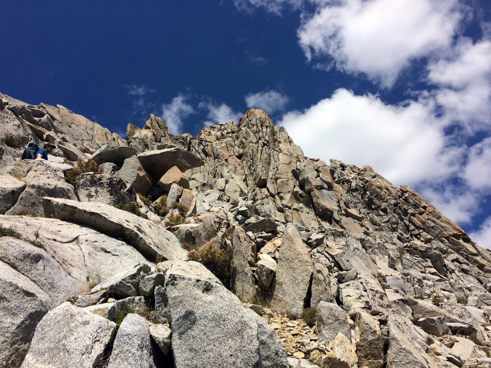
Although straight line distance was perhaps a few miles, we needed to gain 1,500' and drop 2,000' feet all over unknown terrain. Our plan was to climb the Whaleback via the East Face - Class 3. However, since we had our backpacks with us we needed to make this a carry over. Going direct to the summit might had being too time consuming with our bags. We decided to climb to what we thought was the "crossing" to the Southwest Face - Class 3. From there, we would drop our bags and tag the summit via class 3, double back and grab our bags, descent the Southwest face. Simple enough right?

The first two hours of morning were very mellow as we descended back down the Colby Pass trail to the lower drainage where the East Face of the Whaleback meets up. Pictured below is shot looking back down the drainage with east face of the Whaleback on the left.

Below is a shot of the east face. I marked our approximate route up to what we thought would be the crossing to the west side. The only unknown was if indeed the other side was where the Southwest face route linked up. If we had gone up and over much further left (south), that would be perhaps too long of a back track to tag the summit.

We left the Colby pass trail around the 10,400' mark and traversed across slabs to the start of what we thought was the east face route.

Above: Nate scoping out the east face of the Whaleback.
Below: Our approximate route up to the crossing. Nothing more than 2nd class until the last few feet then 3rd.


Above: Sublime alpine.
Below: It took us one hour to climb the east face up to the crossing. Fortunately, the weather was much more cooperative today.

Above: Okay - the crossing. Not what we were hoping for. This is looking back on the spine of the Whaleback (south). We needed to be further down the ridge to where the pine trees ascend the west face for our descent into Cloud Canyon.
Below: Looking north in the direction of the summit. Many false summits, but if you zoom in, the actual summit is the far off point on the left. And.... not even close to 3rd class. This looked 4th and possible cliff outs if we stayed on the ridge to the summit.

Above: We dropped our bags at our crossing point and then decided to descend back down the east face to aid in traversing around ridge towers and cliffs.
Below: Solid 4th class along the ridge line proper.

I lead the charge and after going around a few gullies, I started to move back up to the ridge line proper to find the summit. I didn't quite realize just how far away we where from the actual summit. Once I arrived back on the ridge I could tell it was going to be 4th class with some gnarly exposure (Hell yea!!). However, Nate had enough fun for the day and returned to our bags. As I began the traverse to the summit, I could note places where I believe the legit East Face route ascends to the summit keeping the climbing well within 3rd class. In order to make this route work from the ridge, one would have to descend several hundred feet in gullies to join. I opted to commit to the ridge and enjoy the ride.

Above: Summit register.
Below: Whaleback quest complete - summit 11,717'


Above: The one and only Cloud Canyon from the summit of the Whaleback.
Below: Glacier Ridge 12,360'. Funny can't find any info on what looks to be the east ridge? I mean what a ridge!


Above: Looking across to the Kings - Kern Divide. Here we see from right to left, Milestone Mountain (13,641'), Midway Mountain (13,666') and just off the far left of the picture would be Table Mountain (13,630').
Below: It was time to head back to Nate, and the last thing I wanted was to descend a couple of hundred feet to traverse the east face. Once again, I opted to stick to the ridge proper and found some serious 4th class. Side note: This may be the "Reddish Head wall" which is found in the description of the Secor's East Route in Peaks, Passes, and Trails.


Above: There is a route (I believe this gully is it) on the west face known as the "Blowhole Route". Taking note of our backpacks and the unknown variable of descending a 4th class route, we opted to take our chances continuing to traverse the South ridge towards the saddle in which the southwest face route crosses over.
Below: I stuck 100% the ridge from the summit back down to Nate. What a wild 30 minute ride that was. Solid 4th and great exposure.


Above: And then there we were at the wrong crossing with our backpacks needing to traverse south. For the most part we stuck to the ridge. Dropping down left (east) was a series of gullies with 3rd class ribs separating them. 4th to 5th class awaited on the right side (west) of the ridge.
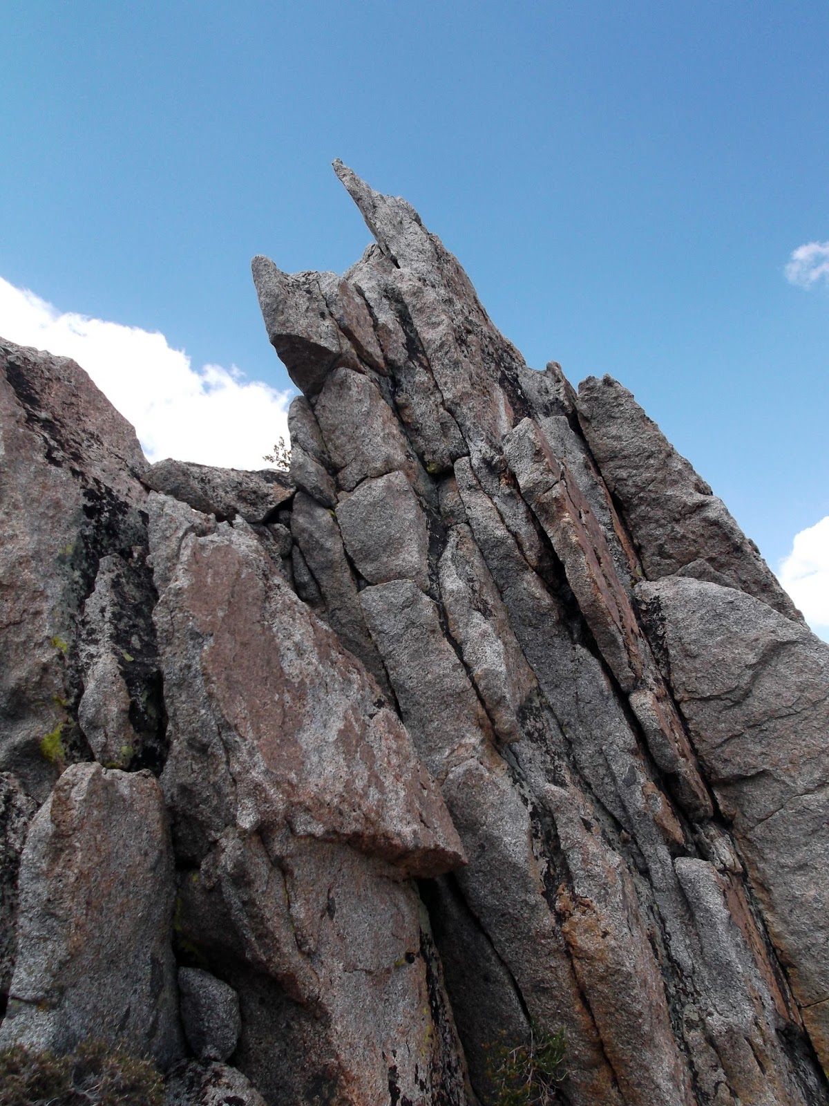
Below: Continuous small towers guarded the ridge for almost 45 minutes of climbing. I found that sometimes passing them on their right (west) side was the best.

Above: Looking back on the South Ridge of the Whaleback. So here is the deal. I've searched internet trip reports and guide books looking for a description of exactly what Nate and I did. Summit to the low saddle where the Southwest face route crosses over to join the the ridge - I define that as the South ridge of the Whaleback. I highly doubt we were the first to do it, but if nobody puts it on the internet, did it really happen?
Below: Nate stoked the gnarly South Ridge is over.


Above: No wait, still more of the south ridge.
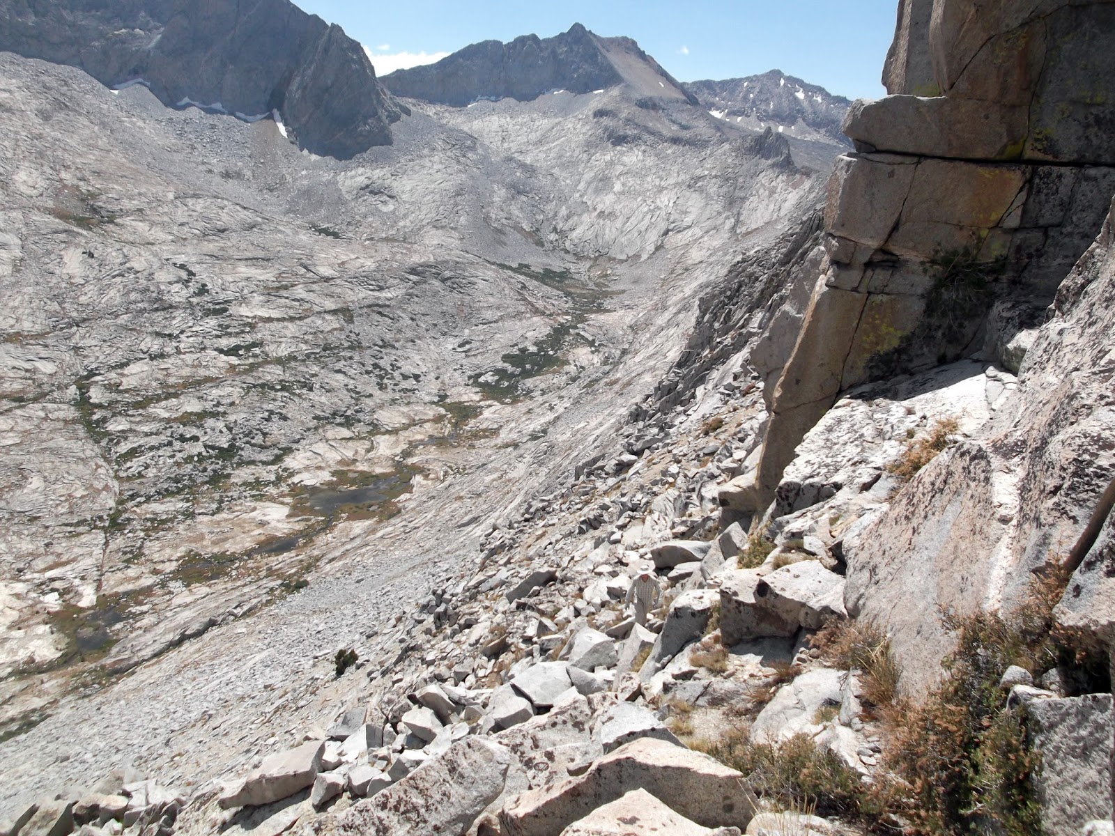
Below: Alright, 6 hours after starting up the east face we reach the saddle and drop down on to the southwest face (class 3). It was slow and tedious going back down to the meadow in Cloud Canyon.


Above: Burnt out from our crossing of the Whaleback, we stroll up Cloud Canyon in search of a campsite.
Below: At the head of Cloud Canyon the rock turns from granite to some kind of red schist. A really cool mini gorge had been dug out by the creek. In fact this whole area reminded me of White Chief in the Mineral King region (just missing the white marble!)


Above: This site was a 3 out of 10 in regards to quality of site but the location was insane!
Below: Triple Divide Peak (12,634')

Thursday August 25th 2016 - Cloud Canyon - Tablelands:
I had an amazing morning watching the sunrise over the Whaleback in Cloud canyon drinking my coffee. I'll always remember this morning.
We had a big day in front of us. Our plan was cross both Copper Mine Pass (legit) and then Horn col to camp at Lonely Lake.

We launched off from our camp at the head of Cloud Canyon by 9am. I wanted so badly to find this old "road" to see what that was all about. We traveled for several hours making our way up the side of the canyon and then to Copper Mine Peak which is labeled Peak 12,345' on maps.

Above: The complete upper Cloud Canyon with the Whaleback.
Below: The hike up to Copper Mine pass.


Above: Yet even higher up on the trek to Copper Mine pass.
Below: Again, the original pass goes within 20' feet of the summit of this peak. The last couple of hundred feet towards the summit a use trail began to emerge. Not really a road....


Above: Copper Mine Pass (original, legit, not Secor's, etc). I've been to almost every 14er in this state and hadn't seen a view like this before. It was a 365 degree view looking back on Cloud and Deadman's canyon, the whole Kaweah drainage, the massive Kaweah Range, and the rest of the Great Western Divide. It was quite the site.
Below: Hamilton Dome (9,745') and Hamilton Towers.


Above: Nate takes it all in. Kings-Kern divide to the left, Whitney far off distant right.
Below: A lot of action going on here. But generally we're looking at Kaweah Queen, Black Kaweah, and Red Kaweah. Definitely rough terrain.


Above: We chilled atop Peak 12,345' which is really Copper Mine Pass for well over an hour. The views where too good to leave.
Below: Once we did decide to split, there was actually a really nice use trail straddling the ridge between the Kaweah drainage and Deadman's Canyon (Elizabeth Pass & Horn Col can be seen).

- I didn't realize it at the time we were going by this area, but the high point there on the left is in the region of the top out section for the ridge climb known as Saber Ridge. I've been told this is a must do and actually even came close to securing plan to get out and climb in during the summer of 2016. Now at least, I'm familiar with the area somewhat...

Above: Looking back on Peak 12,345 (Copper Mine Pass). Pictured off camera left is a saddle which is what Secor describes as Copper mine pass.
Below: And here it is. The absolutely most random mine. This thing was in the middle of nowhere. I can't even begin to understand what those miners where thinking.


Above: Copper indeed.
Below: Deadman's Canyon is the most perfect example of a glaciated canyon I've seen!


Above: Our day continued on as we traversed the head of Deadman's Canyon on our way to Horn Col. Along the way we passed over the Elizabeth pass trail even seeing hikers at the pass.
Below: Again, what an amazing looking place.


Above: Horn Col - 4pm, 7 hours after starting and getting a little tired. It's actually a really cool little saddle and just amazing views in all directions.
Below: Lonely Lake which was our destination for the night. Now scope it out in the picture below - "Pterodactyl Pass" is the low spot dead center next to the horned point. This is the crossing in to the Tablelands. Nate and I stood atop Horn Col and realized the scale plus a huge drainage in between there and Lonely Lake. We decided to take the edge off of our last day and keep on moving up and over to Tablelands.


Above: You can see why it's named Horn Col.
Below: You know what? Screw Pterodactyl Pass. We just went straight up and over the mountain in the foreground which is I suppose known as Big Bird Peak.


Above: Yeah... Big Bird Lake and Deadman's Canyon.
Below: What a sight! This was taken at the saddle between Lonely Lake and Big Bird Lake but it was a sheer drop down the north side.


Above: More Hamilton Dome and Towers. Far off is Mineral King.
Below: Our late afternoon tired haul up and over Big Bird Peak.


Above: The next few hours really turned into a blur. We crossed Big Bird peak only to find we still had some distance to cover to reach the Tablelands proper. Not only that, but this years lack of rain meant a lot of the tarns up in the Tablelands where dried up. So we had to hike awhile to get to one with water.
Below: The sun set just prior to reaching the first tarn with water. We eventually made camp and mellowed out for the rest of the evening. This place was really an unusual sight in the sierras due to the amount of flat land. It was quite an amazing place to walk around.

Friday August 26th 2016 - Tablelands - Wolverton TH:

Go home day. I'm always excited to go home and see my family but Nate and I were just really starting to get in to the groove. Our walk out of the Tablelands was pretty uneventful and we both enjoyed our stroll through this area.

Above: Looking down the Marble Fork of the Kaweah in the direction of Pear Lake and Lodgepole.
Below: Looking back at the direction of Tablelands.


Above: The Watchtower
Below: Peak Lake Ski Hut.

...stumbling upon the ski hut we returned to groomed trail and back to civilization. It's about 5 miles back to the trail head from Pear Lake and we came across more people during this section than we came across the previous 4 days.
We both arrived at my parked car by 3pm and headed off to go retrieve Nate's car back at the Marvin Pass TH.
This was one of the better backpacking trips I've had in the Sierras. Again, it felt like everything was in its right place out there. I could of course go on in detail about how my new shoes destroyed my feet with some of the worse blisters I've ever had, but we're all done listening to that old story. I thoroughly enjoyed our one-way travel through Southern Kings Canyon National Park. The views from atop Copper Mine Pass were unlike any I've seen before and the insane air we got on the south ridge of the Whaleback was memorable!
until next time...toodles!