Russ had hiked this as well, and according to him it was, "Insanely beautiful." Generally, most guidebooks indicate that this loop is the perfect long back country experience. My plan: Light and Fast! I would pack food and fuel for 3 days but if I could do it all in two longs days that would be the goal.
The loop is 41.1 miles long and has an elevation gain of 5,035' to the high point of Glenn Pass (11,978'). Due to the popularity of this hike, the quota for the trail head is generally book months in advance. The park keeps a small percentage of walk up permits available per day. So, I HAD to be at the permitting station which is at the trail (Roads End) by 7 AM. Looks like an early start for me out of Fresno.
Tuesday August 16th 2011:
I left Fresno at 4 AM and drove a little over 2 and a half hours to the end of highway 180 (known as Roads End). The drive down from Grants Grove to the bottom the the Kings Canyon is very impressive! I arrived in the parking a little before 7 AM and just in time to walk up to the permitting shack at the trail head parking lot. The ranger issues me a walk up permit and by 7:30 AM I was walking down the trail to a beautiful morning.


From the trail head it is 1.9 flat miles along the Kings River to the trail junction with Bubbs creek. After this turn it would be all new territory for me until I returned to Bubbs Creek back at Junction meadow (another 30 miles from here). First up was Mist Falls at 3.9 miles from the TH.
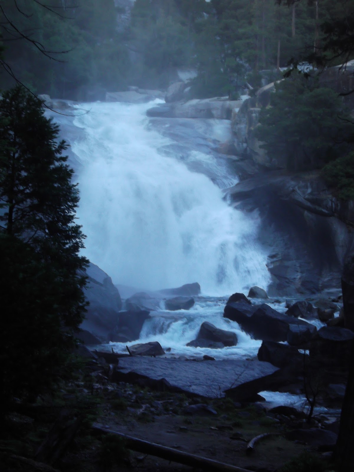

The falls were really pretty impressive and even for August there was a large amount of water flowing in the river still. The trail then steeply climbs up out of the lower canyon into what is known as Paradise Canyon. The first flat and forestry site on the trail after the climb is known as Lower Paradise and this is also the first legal camping from the TH. Total mileage from the TH is 5.7 miles.


The next four miles through Paradise canyon are pretty mellow (not totally flat.) Great views of the leisurely meandering south fork of the Kings are seen by the trail. After 10 miles from the TH the trail crosses the south fork at what is known as Upper Paradise then starts ascending the Woods Creek drainage. The time was noon and I was making excellent progress. However, the daytime heat was starting to buildup and I noticed my pace starting to slow on the climb up Woods Creek.
Although it was getting hot and I was starting to tire, the views of the deep back-country were very nice!


Pictured above one of the "Castle Domes" in the Woods Creek drainage.
After 15.7 miles and 8 hours of hiking, I reached the John Muir Trail junction. It is here the loop turns south and follows the JMT towards Rae Lakes basin. One heck of an impressive swigging bridge has been built for the JMT crossing Woods Creek.

From the crossing, the JMT then begins to climb from an election of 8,500' to the first of the many Rae Lakes (Dollar Like is first) at an elevation of 10,200'.

Baxter Lake and Pass are in the above drainage.

Fatigue was starting to set into effect and I began to look around for descent camp site selection. However, as the JMT continued to climb up and out of the forest, the terrain became more and more rockier so I became committed to getting to at least Dollar Lake at 19.7 miles from the TH.

Finally, a little after 7 PM, almost 12 hours after starting I reached Dollar Lake. It was really a beautiful place with great views of the the Fin Dome (seen above). As usual with this 2011 wet year, the mosquitoes came out in force when the sun set. I retired to my tent and had a great nights sleep.
Wednesday August 17th 2011:
By 7:30 AM I was off back on the trail again. It was cool morning but not cold and the mosquitoes were out but not bad. After Dollar lake, the trail continues to mellowly climb past Arrowhead Lake then a few smaller lakes as the views really start to open up.

Above: Outlet of Arrowhead lake with The Fin Dome (11,693').
Below: Mt. Cotter (12,721').


Above: Looking back north across Arrowhead lake and far off Crater Mountain (12,874')
Below: The Fin Dome!

After an hour and a half of hiking the first of the many Rae Lakes is reached. This location is 22.7 miles from the TH. The views of the surrounding mountains from these pristine lakes is just amazing!


The beautiful looking mountain in these pictures is call the "Painted Lady" (12,126'). Travel through the lakes was shorted lived and it was time to ascend Glen Pass before it got too warm out. From the turnoff to Sixty Lakes Basin it took me an hour and forty minutes to climb up to the pass. The views of Rae Lakes, the Painted Lady, and near by bowls was really nice!

Above: Many stream crossings while hiking towards the pass.
Below: The JMT was busy this morning,


Above: Glenn Pass seen as the low spot on the ridge above.
Below; The last of the winters snow hanging on the just prior to the pass.

I reached the pass at 11:30 AM and took a brief break to enjoy the views. There had to be at least 10 other people up there, mostly through hikers on the JMT. It was all downhill from here so to speak so I decided that the next few hours would really determine if I was going to spend another night out here or if I could make this loop in 2 days.

Above: The East Ridge of Mt. Brewer (13,570').
Below: A high unnamed lake on the south side of Glen Pass.


Above: The JMT doesn't actually go by Charlotte Lake (10,400') but a side trail will take one there.
Below: Shortly after the Charlotte lake junction the JMT dips over a ridge and down 1,000' in to Bubbs Creek drainage. Seen here is an impressive view of the East Vidette (12,350') and Center Basin on the left.


Above: At the junction of the JMT and Bubbs creek trail (28.2 miles from TH) the loop then turns right and follows Bubbs creek all the way out.
Below: By 3:30 in the afternoon I was getting a little tired but not to the point of calling it a day. My plan was to reach Junction Meadow which would be 10.3 miles remaining and make the call from there. I determined an hour long break by the creek would recharge me and I would finish off the trip.

After Junction meadow it was a long haul out ten miles. Although the miles floated by, my feet were telling me that this was over. I had just hiked this section of trail the previous year ironically with sore feet as well. Guess I was domed to repeat it. Only a few way points pass as the mileage continues by. Charlotte Creek crossing is at mile 33.9 and then the Sphinx trail junction is at 37.5. This is also the last campsite until the trail head from this direction.


At 8:30 PM, I arrived back the the Roads End trail head, 13 hours of hiking. When it was all said and done, pulling the Rae Lakes Loop off in two days is a serious haul but I felt worth it. This was one of the more amazing scenic trips I've ever taken in the Sierras!
Stats:
- Miles 41.1
- Total Hiking Time: 23 hours
- Car to Car Time: 37 hours
- Garage to Garage: 43 hours