It's been one of the more busier years I've had on the work front, making for a slow summer in the Sierras. Kristine and I made a rainy yet fun overnight backpacking trip to Cathedral Lakes, then a day hike to the first Dinkey Lakes with our dog. Short of that, I've been maxed at work!

Above: Kristine poses her rain gear on our trip to Cathedral Lakes.
Below: Nala poses at the first Dinkey Lake

A former co-worker of mine at SkyWest Nate, wanted to get together for a back-country hike. His backpacking resume is impressive including the John Muir Trail and many other interesting remote peaks. He proposed an intriguing route that involved everything from heavy use trail to brush whacking.
We would start off at the Bear Ridge (not Creek) Trail head, and hike up to join the JMT. To start we would begin to cross country up and over Recess Pass to camp at First Recess Lake. From there the route was again to XC down in to the 2nd Recess, and join up with a trail which reportedly went over Gabbot Pass to find Lake Italy on the other side. From Lake Italy we would find the remains of the unmaintained Italy Pass trail and follow that back down to the Hilgard branch to once again join the JMT. Following the JMT just for a few miles we would then hike out Bear Creek (not Ridge) to loop back around to the car. 30+ miles, Two 12,000' XC passes and an area I'd never been too.
I couldn't say no to a trip like this....

Sunday August 23rd, 2015:
I rallied at Nate's place in Clovis, and we drove up in his car to the Bear Creek Cutoff trail head. By 10:00 we were off, and conditions were hot and VERY smoky. The Rough Fire in Kings Canyon was blowing northeast making poor visibility. Fair warning, the photos on this trip I had to process a lot to see anything from the smoke.

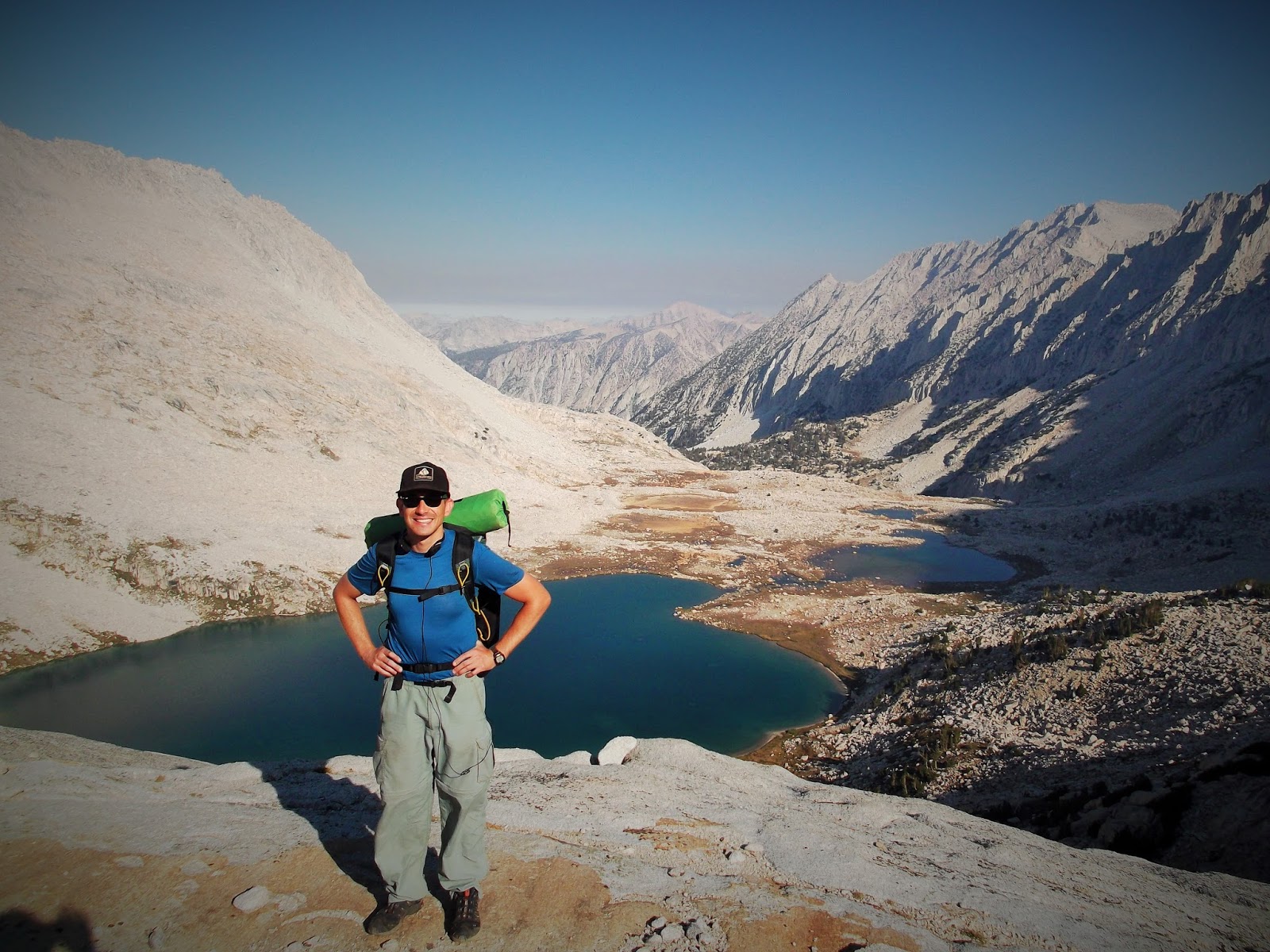
After a half mile walk along the Edison Lake road, we reached the Bear RIDGE trail head. To make for a more interesting loop, Nate suggested we leave from one trail head and finish at the other. The two are only separated by that half mile walk on the road. Again, this being my first time in the area, I was along for the ride. The Bear Ridge trail climbs the divide between Bear Creek and Mono Creek (which is dammed to make Edison Lake). Hot, steep, and dusty is the best description of this 5 mile trail up to the John Muir Trail. Pictured above is Edison Lake close to empty from the drought. Nate is seen below as we hike the Bear Ridge trail.

A little over two hours later we arrived at the intersection of the Bear Ridge trail and the JMT. I had passed through this section in 2012 . We paused for some lunch and then we're soon off to cross country from there.

Above: Our route once leaving the intersection of the JMT & Bear Ridge trail.
Below: Hot, smokey, but otherwise smooth going.


Above: I apologize for the quality of the picture, but the smoke was pretty bad. This is best I could get this picture. I also circled our objective, "Recess Pass".
Below: Hours later we begin to punch up out of the shrub on our climb up to Recess Pass. The heat and smoke took it's toll on both of us.


Above: We worked our way up and towards the low saddle which we can only guess would be the pass (11,920'). Finally around, 11,500' or so we seem to get up and above the smoke.
Below: Recess Peak (12,813') and the first recess cirque below.


Above: This is the eastern aspect of the class 2 Recess Pass. Pretty obvious from the east. However, we approached the pass from the west. It took some time to find, but was obvious compared to the cliffed out 4th class walls around it. For scale, Nate can been seen in this photo. Can you spot him?
Below: After a long day, we eventually reached our camp at the First Recess Lake (11,200')

Monday August 24th, 2015:
Our first day was pretty taxing, and we were on the fence about continuing due to the smoke. However, after a relaxing morning at our camp we both seemed eager to launch off on our 2nd day. So, take a look at the Google Earth picture below. Our camp was a the lake in the lower right. Today's objective was to cross the saddle between the first recess and drop down (2,000') in to the 2nd and larger recess. We would then head up the steep canyon wall into the Mills Creek drainage and try to go over Gabbot Pass (12,240').


Above: Nate surveys Recess peak and our route the previous evening from Recess Pass.
Below; Nate surveys the 2nd smoke filled Recess from the saddle between the fist & second recess.


Above: As with most cross country travel, one always greatly underestimates difficulty and time required. After briefing enjoying a used trail at the bottom the 2nd Recess we fought slab, bushes, and heat up the Mills Creek drainage.
Below: This is looking BACK on our cross country route over the saddle between the 1st and 2nd Recess, then down 2,000' to the creek and back up.


Above: Spending most of our day working our way up the Mills Creek drainage, we eventually got above the tree line and travel became more enjoyable. This is taken a Lower Mills Lake looking up the drainage towards Gabbot Pass. Mount Abbot (13,704') is seen left of the pass.
Below: After a strenuous day of cross country travel we stopped our hike at upper Mills Lake (11,200'). As the sun set, the smoke would settle letting the sun come out.

Tuesday August 25th, 2015:
We launched earlier in the morning than the previous day to get a cool start on the climb over Gabbot pass. Although still smokey, it didn't seem as bad as the previous two days.
Above: Looking back on our camp at Upper Mills Lake
Below: A little morning ice on a small glacial tarn below Gabbot Pass.


Above: This is the driest year I've seen in the back country. Still at times the most amazing flowers grow from nothing.
Below: Two hours after starting off, we reached Gabbot Pass (12,240'). We dropped out back packs and scrambled about 500' up the east ridge of Mount Gabb (13,741'). Seen here is Gabbot Pass middle left with the upper Lake Italy basin sloping downward to the right. Nate is posing lower center while the western aspect of the Bear Creek Spire is seen as the high point direct center. In fact, the North Arete can be clearly seen dropping down left from the summit. I climbed this route in June 2012 with the famed Matthew Greene. Matt went missing the following the summer and yet to be found.


Above: From our trip high point (13,000'), there was a great vantage point to view the surrounding area. Seen here a nice drop out over the northern side of Mount Gabb looking back towards the Mills Lake.
Below: About 700' of class 2 turning to 3 along the east ridge of Mount Gabb. Both Nate and I had no desire to toil with that.


Above: It took me some time and I had to cross check some maps once I got home, but this is the west side of the Petit Griffon! Sort of an obscure technical rock climb with a 4 star, 5.7 climb!
Below: Nate scoping some air on the east ridge of Gabb.


Above: Our hike from Gabbot Pass down to Lake Italy was pleasant and took about an hour. We stopped to enjoy lunch on the lake shore. Having seen Lake Italy many times from the air, it was cool to see it in person.
Below: A nice use trail skirts the northern shore of lake Italy. From one end to the other is about a mile and a half long. Really long for high sierra lakes! An amazing place, but Nate noted this place looked like it could be a serious wind tunnel and probably not the best place to camp.


Above: Overview image of our descent via the "remains" of the Italy Pass trail to the JMT.
Below: The used/maintained/stock/markers trail which makes the Italy Pass trail losses about 2,000' over 6 miles to the junction of the John Muir Trail.

Wednesday August 26th, 2015:
The previous day was a big day. We eventually camped just pass the junction of the JMT & the Bear Creek Trail. Nate had hiked this trail a few times before and knew of a good campsite. It was a mellow 10 miles out that morning and about 4 hours after hitting the trail we were back to the car.
Overall, this was an amazing backpacking trip. With the exception of the 2 miles we traversed along the JMT - this was ALL new territory for me! I want to thank Nate for being excellent company along the trail and proposing this unique way of seeing the Mono Recesses.